Revision History
|
K |
Revised Section 2.1.1, 2.1.2 & 2.4 of Appendix A as per the Marine Mammal Watching Plan (Rev I) |
21 August 2020 |
|
J |
Added Footnote (1) in Figure 3.4 |
16 July 2019 |
|
I |
Revision on last sentence of Section 3.2.3 |
28 May 2019 |
|
H |
Revised as per EPDs comment |
7 March 2019 |
|
G |
Revision on Section 1.5, 5.4.1, 5.5.1, 5.9.1 & 7, Appendix A, B & C |
20 December 2018 |
|
F |
Revised as per EPD & AFCDs comment |
11 July 2018 |
|
E |
Revised as per AFCDs comment |
4 July 2018 |
|
D |
Revised as per AFCDs comment |
26 June 2018 |
|
C |
Revised as per IECs comment |
21 May 2018 |
|
B |
Revised as per IECs comment |
12 May 2018 |
|
A |
First Issue for Comments |
26 March 2018 |
|
Rev. |
Description of Modification |
Date |
Content
2) Construction Phase Monitoring Programme for Finless Porpoise
3) Proposed Marine Mammal Monitoring Programme during Construction Phases
4) Proposed Marine Mammal Monitoring Programme during Operational Phase
5) Recommended Mitigation Measures to Avoid Disturbance to Marine Mammal.
6) Reporting Works for Monitoring of Marine Mammal
Figures
Figure 3.1 Line Transects for Marine Mammal Surveys
Figure 3.2 Locations of Passive Acoustic Monitoring
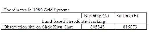
Figure 3.3 Locations of Land-based Theodolite Tracking
Figure 3.4 Construction Phase Marine Mammal Monitoring Schedule
Figure 4.1 Line Transects for Marine Mammal Surveys
Figure 4.2 Locations of Passive Acoustic Monitoring
Figure 4.3 Locations of Land-based Theodolite Tracking
Figure 4.4 Marine Travel Routes During Operational Stage
Figure 5.1 Response Procedures for Occurrence of Marine Mammal within Silt Curtain
Figure 5.2 Location of Installation of Floating Type Silt Curtain
Figure 5.3 Density of finless porpoises with corrected survey effort per km2 in southern waters of Hong Kong during peak season (December to May), using data collected during 2007-16
Figure 5.4 Density of finless porpoises with corrected survey effort per km2 in Southeast Lantau survey area during IWMF baseline monitoring period (February-April 2018)
Appendix
Appendix A Marine Mammal Exclusion Zone Plan
Appendix B Implementation Schedule for Mitigation Measures
Appendix C Curriculum Vitae (CV) of ETs Environmental Experts
1.1) The Government of Hong Kong SAR will develop the Integrated Waste Management Facilities (IWMF) Phase 1 (hereafter referred to the Project) with incineration to achieve substantial bulk reduction for unavoidable Municipal Solid Waste (MSW) and to recover energy from incineration process. The IWMF will be on an artificial island to be formed by reclamation at the south-western coast of Shek Kwu Chau (SKC). An Environmental Impact Assessment (EIA) for the Project was conducted according to the EIA Study Brief No. ESB-184/2008. The EIA report (Register No: AEIAR-163/2012) was approved on 17 January 2012 under the Environmental Impact Assessment Ordinance (EIAO). An Environmental Permit (EP) (EP No.: EP-429/2012) was granted on 19 January 2012 for the construction and operation of the Project. A variation of environmental permit (VEP) was subsequently applied and the latest VEP (EP No: EP-429/2012/A) was issued by the Environmental Protection Department (EPD) on 14 October 2016. Application for further environmental permit (FEP) was made on 28 November 2017 and the FEP was granted on 27 December 2017.
1.2) Keppel Seghers Zhen Hua Joint Venture (the JV) has been awarded the Project to carry out reclamation works (including associated dredging works) which is located near the south-western coast of Shek Kwu Chau, and the JV will construct an incinerator and its relevant facilities on the reclaimed land. The tentative construction programme of the IWMF project is shown as Table 1 for reference.
Table 1 Tentative Construction Programme of the IWMF Project
|
Description |
Date |
|
Award of Contract |
22 Nov 2017 |
|
Phase I Construction of Perimeter Seawalls |
10 Jan 2018 21 Jan 2020 |
|
Seawall at DCM Area |
15 Mar 2018 21 Jan 2020 |
|
Seawall at Dredging Area |
22 Aug 2018 09 Sept 2019 |
|
Phase II Reclamation, Breakwater and Berth Construction |
22 Sept 2019 27 Jun 2021 |
|
Reclamation |
22 Sept 2019 27 Jun 2021 |
|
Breakwater |
22 Sept 2019 07 Mar 2021 |
|
Foundation Works |
12 Apr 2021 13 May 2022 |
|
Superstructure Works |
12 Aug 2021 12 Jan 2023 |
|
Architectural Builders Works and Finishes |
07 Nov 2021 09 Sept 2023 |
|
Building Services Installation |
20 Feb 2022 20 Oct 2023 |
|
Process Equipment Installation |
27 Jan 2022 04 Nov 2023 |
|
Landscape, External Road and Drains Works |
07 Nov 2021 26 Apr 2024 |
1.3) According to the Condition 2.9 of the FEP, a Detailed Monitoring Programme on Finless Porpoise monitoring plan shall be prepared at least one month before the commencement of construction of the Project to propose the monitoring frequency and mitigation measures to be taken to avoid disturbance to Finless Porpoise.
1.4) The EIA Report revealed that the reclamation and relevant marine works of the Project will adversely affect the existing Finless Porpoise near or within the Project site as they have been frequently and consistently found between the waters of Soko Islands and Shek Kwu Chau according to the Final Reports of Agriculture, Fisheries and Conservation Department (AFCD) for Monitoring of Marine Mammals in Hong Kong Waters Data Collection (from 2014 to 2017). The Finless Porpoise is one of the protected marine mammal in Hong Kong. In order to prevent adverse impacts arising from the Project on marine mammals, the EIA Study has recommended the implementation of a marine mammal monitoring programme during pre-construction, construction and operation phases of the Project.
1.5) In order to implement the EIA recommendation, our company ASCL partners with the experienced Marine Ecologist, Dr. Samuel Hung, Dr. Lindsay Porter, Ms. Julia Chan or someone with equivalent qualifications as the marine mammal specialist of the ET. Each of them has more than 15 years professional experience on Marine Mammal Monitoring Surveys in Hong Kong Waters. Marine mammal specialist of the ET of the Project will assist to plan and advise the monitoring of Finless Porpoise in pre-construction phase, construction phase and operation phase of the Project.
2) Construction Phase Monitoring Programme for Finless Porpoise
2.1.1) The marine mammal monitoring programme would focus on Finless Porpoise, as the study area near Shek Kwu Chau has been identified as a hotspot for this species, while the Chinese White Dolphins rarely occurred there in the past. The monitoring would verify the predicted impacts on marine mammals, and examine whether the mitigation measures recommended in the EIA report have been effectively implemented to protect marine mammals from negative impacts from construction activities. The marine mammal monitoring programme should cover pre-construction phase, construction phase, and operation phase.
2.1.2) The pre-construction monitoring (i.e. baseline survey before construction) have been conducted with three parts of baseline marine mammal monitoring conducted prior to the commencement of works and agreed with AFCD, namely the Vessel-based Line-transect Survey, Passive Acoustic Monitoring and Land-based Theodolite Tracking, which were carried out between 30 January 2018 and 14 May 2018, covering the several months within the peak season for Finless Porpoise occurrence (i.e. December to May). In total, 56 groups of finless porpoise, numbering 148 individuals, and only two groups of two Chinese White Dolphins were observed in Southeast Lantau waters during the three-month Vessel-based Line-transect Survey from February to April 2018, the porpoises were sighted evenly throughout most of the Southeast Lantau survey area, with the exception of the southeastern portion of offshore waters where no porpoise was sighted. More porpoises apparently occurred to the eastern and southern sides of Shek Kwu Chau, and in the waters between Shek Kwu Chau and the Soko Islands. On the contrary, they were less frequently sighted in the inshore waters of Lantau Island (i.e. Pui O Wan) as well as between the waters between Cheung Chau and Shek Kwu Chau.
2.1.3) The Vessel-based Line-transect Survey , the Passive Acoustic Monitoring and the Land-based Theodolite Tracking will be conducted to provide systematic, quantitative measurements of occurrence, encounter rate, habitat use, movement and behavioral patterns of marine mammals within or near the Project Area during construction and operational phases.
3) Proposed Marine Mammal Monitoring Programme during Construction Phases
3.1) Objectives of Construction Phase Marine Mammal Monitoring
3.1.1) The mammal monitoring works during construction consist of the following three survey methods:
a) Vessel-based Line-transect Survey to monitor the occurrence of Finless Porpoises (and Chinese White Dolphins) in the study area during construction works, by comparing with the findings of the pre-construction marine mammal monitoring;
b) Passive Acoustic Monitoring to study the usage of the Project Area and two control sites in South Lantau Waters by Finless Porpoise during construction works, in reference with the baseline findings of the pre-construction marine mammal monitoring; and
c) Land-based Theodolite Tracking to study the movement and behavioural pattern of Finless Porpoise within and around the Project Area during construction works.
3.2) Vessel-based Line-transect Survey
3.2.1) For the vessel-based marine mammal surveys, the monitoring team adopted the standard line-transect method (Buckland et al. 2001) as same as that adopted during the EIA study and pre-construction phase monitoring to allow fair comparison of marine mammal monitoring results. The collected survey data would then be compatible with the long-term marine mammal monitoring programme commissioned by AFCD to allow potential comparisons and pooling data for various analyses.
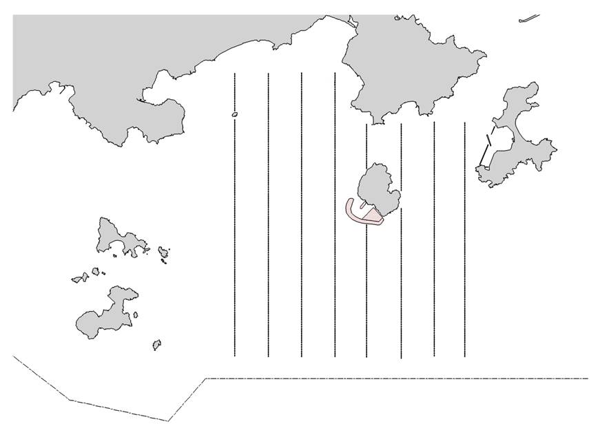
3.2.2) Eight transect lines are set at Southeast Lantau survey area, including Shek Kwu Chau, waters between Shek Kwu Chau and the Soko Islands, inshore waters of Lantau Island (e.g. Pui O Wan) as well as southwest corner of Cheung Chau as shown in Figure 3.1 below:
|
|
Figure 3.1 Line Transects for Marine Mammal Surveys |
3.2.3) The surveys should cover all 4 seasons in order to take natural fluctuation and seasonal variations into account for data analysis of distribution, encounter rate, density and habitat use of both porpoises and dolphins (if any). In comparison to the baseline monitoring results, results from the analyzed construction phase monitoring data would allow the detection of any changes of their usage of habitat, in response to the scheduled construction works. The monitoring surveys shall be conducted throughout the construction phase involving marine construction works, with the frequency shown in Table 3.1 below:
Table 3.1 Vessel-based Line-transect Survey Frequency
|
Season |
Months |
Frequency |
|
Peak Season |
December, January, February, March, April & May |
Twice per month |
|
Non-peak Season |
June, July, August, September, October & November |
Once per month |
3.2.4) For each vessel survey, a 15-m inboard vessel with an open upper deck (about 4.5 m above water surface) would be used to make observations from the flying bridge area. Two experienced marine mammal observers (a data recorder and a primary observer) would make up the on-effort survey team, and the survey vessel would transit different transect lines at a constant speed of 13-15 km per hour. The data recorder shall search with unaided eyes and fill out the datasheets, while the primary observer shall search for dolphins and porpoises continuously through 7 x 50 marine binoculars. Both observers shall search the sea ahead of the vessel, between 270o and 90o (in relation to the bow, which is defined as 0o). Two additional experienced observers shall be available on the boat to work in shift (i.e. rotate every 30 minutes) in order to minimize fatigue of the survey team members. All observers shall be experienced in small cetacean survey techniques and identifying local cetacean species with extensive training by marine mammal specialist of the ET
.
3.2.5) During on-effort survey periods, the survey team shall record effort data including time, position (latitude and longitude), weather conditions (Beaufort sea state and visibility), and distance traveled in each series (a continuous period of search effort) with the assistance of a handheld GPS (Garmin eTrex Legend). Data including time, position and vessel speed would also be automatically and continuously logged by handheld GPS throughout the entire survey for subsequent review.
3.2.6) When porpoises or dolphins are sighted, the survey team shall end the survey effort, and immediately record the initial sighting distance and angle of the porpoise or dolphin group from the survey vessel, as well as the sighting time and position. Then the research vessel shall be diverted from its course to approach the animals for species identification, group size estimation, assessment of group composition, behavioural observations, and collection of identification photos (feasible only for Chinese White Dolphin). The perpendicular distance (PSD) of the porpoise or dolphin group to the transect line would then be calculated from the initial sighting distance and angle, which shall be used in the line-transect analysis for density and abundance estimation.
3.2.7) The line-transect survey data shall be integrated with a Geographic Information System (GIS) to visualize and interpret different spatial and temporal patterns of porpoise and dolphin distribution using their sighting positions collected from vessel surveys. Location data of porpoise and dolphin groups would be plotted on map layers of Hong Kong using a desktop GIS (e.g. ArcView© 3.1) to examine their distribution patterns in details. The encounter rate could be used as an indicator to determine areas or time periods of importance to porpoises within the study area. For encounter rate analysis of finless porpoises, only survey data collected under Beaufort 2 or below condition would be used for encounter rate analysis.
3.2.8) To take into account of the variations of survey effort across different sections within survey area, the quantitative grid analysis of habitat use would be conducted to examine finless porpoise usage among 1-km2 grids within the Southeast Lantau survey area. For the grid analysis, SPSE (sighting density) and DPSE (porpoise density) values would be deduced for evaluation on level of porpoise usage. First, positions of on-effort porpoise sightings from the study period are plotted onto 68 grids (1 km x 1 km each) within the survey area. Sighting density grids and porpoise density grids shall then be normalized with the amount of survey effort conducted within each grid. The total amount of survey effort spent on each grid shall be calculated by examining the survey coverage on each line-transect survey to determine how many times the grid had been surveyed during study period. With the amount of survey effort calculated for each grid, the sighting density and porpoise density of each grid shall be further normalized (i.e. divided by the unit of survey effort).
3.2.9) The newly-derived unit for sighting density was termed SPSE, representing the number of on-effort sightings per 100 units of survey effort. In addition, the derived unit for actual porpoise density was termed DPSE, representing the number of dolphins/porpoise per 100 units of survey effort. Among the 1-km2 grids that were partially covered by land, the percentage of sea area was calculated using GIS tools, and their SPSE and DPSE values were adjusted accordingly. The following formulae shall be used to estimate SPSE and DPSE in each 1-km2 grid within the study area:
SPSE = ((S / E) x 100) / SA%
DPSE = ((D / E) x 100) / SA%
where S = total number of on-effort sightings
D = total number of dolphins/porpoises from on-effort sightings
E = total number of units of survey effort
SA% = percentage of sea area
3.3) Passive Acoustic Monitoring (PAM)
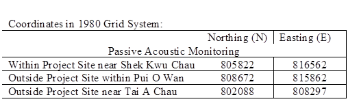
3.3.1) The PAM aims to study the usage of an area by Finless Porpoise by using an array of automated static porpoise detectors (e.g. C-POD) which would be deployed at different locations to detect the unique ultra-high frequency sounds produced by Finless Porpoise. During the construction period, the PAM survey will be conducted including placement of two passive porpoise detectors outside the Project Area as control site (i.e. within Pui O Wan and to the south of Tai A Chau) and one porpoise detector within the Project Area (i.e. near Shek Kwu Chau) as shown in Figure 3.2 below.
|

|
|||
|
Figure 3.2 Locations of Passive Acoustic Monitoring |
3.3.2) These three detectors will be deployed on-site to carry out 24-hours monitoring for a period listed as Table 3.2 below during the construction phase.
Table 3.2 PAM Deployment Period
|
Season |
Months |
Deployment Period |
|
Peak Season |
December, January, February, March, April or May |
At least 30 days during the peak months of porpoise occurrence in South Lantau waters |
3.3.3) The automated static porpoise detectors shall detect the presence and number of finless porpoise and Chinese White Dolphins respectively over the deployment period, with the false signal such as boat sonar and sediment transport noise distinguished and filtered out. The detectors shall be deployed and retrieved by professional dive team on the seabed of the three selected location shown in Figure 3.2. During each deployment, the C-POD unit serial numbers as well as the time and date of deployments shall be recorded. Information including the GPS positions and water depth at each of the deployment locations shall also be obtained.
3.3.4) The diel patterns (i.e. 24-hour activity pattern) of finless porpoise occurrence among the three sites at Shek Kwu Chau, Tai A Chau and Pui O Wan shall be analyzed. Peaks and troughs of finless porpoise occurrence per hour of day would be identified and compared with the results obtained from pre-construction monitoring.
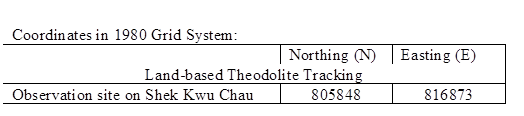
3.4) Land-based Theodolite Tracking
3.4.1) The Land-based Theodolite Tracking study would use the same station as in the AFCD monitoring study(same as the baseline monitoring location), which is situated at the southwest side of Shek Kwu Chau (GPS position: 22o11.47 N and 113o59.33 E) as shown in below Figure 3.3. The station was selected based on its height above sea level (at least 20 metres), close proximity to shore, and relatively unobstructed views of the entire Project Area to the southwest of Shek Kwu Chau. The height of the Shek Kwu Chau Station established by the HKCRP team is 74.6 m high at mean low water, and only a few hundred metres to the IWMF reclamation site, which is ideal for the purpose for the present behavioural and movement monitoring of finless porpoises as well during construction phase considering there as an un-obstructed vantage point at a height above the Project Site.
|

|
|||
|
Figure 3.3 Locations of Land-based Theodolite Tracking |
3.4.2) During the construction phase, Land-based Theodolite Tracking will be carried out for approximately six hours of tracking for each day of field work for a period listed as Table 3.3 below, preferably at the initial stage of the construction period (i.e. December 2018 to May 2019).
Table 3.3 Land-based Theodolite Tracking Survey Period
|
Season |
Months |
Survey Period |
|
Peak Season |
December, January, February, March, April or May |
30 days during the peak months of porpoise occurrence in South Lantau waters |
3.4.3) The monitoring period for land-based theodolite tracking will be proposed to be overlapped with the PAM. The monitoring team consists of one experienced theodolite operator and at least two field observers for assistance. To conduct theodolite tracking, our observers will search systematically for Finless Porpoise using the unaided eye and 7 x 50 handheld binoculars on each survey day throughout the study area. When an individual or group of porpoises is located, a theodolite tracking session will be initiated and focal follow methods will be used to track the porpoise(s). Behavioural state data (i.e. resting, milling, travelling, feeding and socializing) shall also be recorded every 5 minutes for the focal individual or group. Positions of porpoises and boats shall be measured using a digital theodolite connected to a laptop computer. This tracking survey will be conducted during the peak season between December 2018 and May 2019 for 30 surveys spanning across 15-16 weeks during the peak season to provide good temporal coverage during the initial stage of the construction period.
3.5) The proposed monitoring schedule for the above three finless porpoise survey method and the two mitigation measures, namely Marine Mammal Exclusion Zone and Marine Mammal Watching Plan, are illustrated in Figure 3.4 below. Details for the two mitigation measures would be given in Section 5 of this plan.
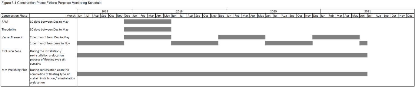
Remark:
(1) The Construction Phase Finless Porpoise Monitoring Schedule shall be reviewed and revised according to updated construction progress.
4) Proposed Marine Mammal Monitoring Programme during Operational Phase
4.1) Objectives of Operational Phase Marine Mammal Monitoring
4.1.1) The mammal monitoring works during 1st year of operation of IWMF consist of the following five survey methods:
a) Vessel-based Line-transect Survey to monitor the occurrence of Finless Porpoises (and Chinese White Dolphins) in the study area during operation, based on the findings of the pre-construction and construction marine mammal monitoring;
b) Passive Acoustic Monitoring to study the usage of the Project Area and two control sites in South Lantau Waters by Finless Porpoise during operation, in reference with the baseline findings of the pre-construction and construction marine mammal monitoring; and
c) Land-based Theodolite Tracking to study the movement and behavioural pattern of Finless Porpoise within and around the Project Area during operation phase.
d) Active Acoustic Monitoring to study the acoustic behaviour of Finless Porpoise in relation to the presence and absence of vessels, and their associated underwater acoustic disturbance.
e) Precautionary Land-based Monitoring of Channel to verify the impact predication of absence of potential trapping of marine mammals within the channel during operational phase.
4.2) Vessel-based Line-transect Survey
4.2.1) For the vessel-based marine mammal surveys, the monitoring team adopted the standard line-transect method (Buckland et al. 2001) as same as that adopted during the EIA study, pre-construction phase and construction phase monitoring to allow fair comparison of marine mammal monitoring results. The collected survey data would then be compatible with the long-term marine mammal monitoring programme commissioned by AFCD to allow potential comparisons and pooling data for various analyses.
4.2.2) Eight transect lines are set at Southeast Lantau survey area, including Shek Kwu Chau, waters between Shek Kwu Chau and the Soko Islands, inshore waters of Lantau Island (e.g. Pui O Wan) as well as southwest corner of Cheung Chau, as same as that adopted during pre-construction phase and construction phase as shown in Figure 4.1.
|
|
Figure 4.1 Line Transects for Marine Mammal Surveys |
4.2.3) The surveys should cover all 4 seasons during 1st year of operation of IWMF in order to take natural fluctuation and seasonal variations into account for data analysis of distribution, encounter rate, density and habitat use of both porpoises and dolphins (if any). In comparison to the baseline and construction phase monitoring results, results from the analyzed operational phase monitoring data would allow the detection of any changes of their usage of habitat, in response to the scheduled construction works. The monitoring surveys shall be conducted throughout the 1st year of operation period with the frequency as same as that adopted during pre-construction phase and construction phase as shown in Table 4.1.
Table 4.1 Vessel-based Line-transect Survey Frequency
|
Season |
Months |
Frequency |
|
Peak Season |
December, January, February, March, April & May |
Twice per month |
|
Non-peak Season |
June, July, August, September, October & November |
Once per month |
4.2.4) The methodology of the operational phase Vessel-based Line-transect Survey will remain the same as those employed during the baseline and construction phases as listed from Section 3.2.4 to 3.2.6 of this plan.
4.2.5) The line-transect survey data shall be integrated with a GIS to visualize and interpret different spatial and temporal patterns of porpoise and dolphin distribution using their sighting positions collected from vessel surveys. Location data of porpoise and dolphin groups would be plotted on map layers of Hong Kong using a desktop GIS to examine their distribution patterns in details. The encounter rate could be used as an indicator to determine areas or time periods of importance to porpoises within the study area. For encounter rate analysis of finless porpoises, only survey data collected under Beaufort 2 or below condition would be used for encounter rate analysis.
4.2.6) To take into account of the variations of survey effort across different sections within survey area, the quantitative grid analysis of habitat use would be conducted to examine finless porpoise usage among 1-km2 grids within the Southeast Lantau survey area. For the grid analysis, SPSE (sighting density) and DPSE (porpoise density) values would be deduced for evaluation on level of porpoise usage. First, positions of on-effort porpoise sightings from the study period are plotted onto 68 grids (1 km x 1 km each) within the survey area. Sighting density grids and porpoise density grids shall then be normalized with the amount of survey effort conducted within each grid. The total amount of survey effort spent on each grid shall be calculated by examining the survey coverage on each line-transect survey to determine how many times the grid had been surveyed during study period. With the amount of survey effort calculated for each grid, the sighting density and porpoise density of each grid shall be further normalized (i.e. divided by the unit of survey effort).
4.2.7) The newly-derived unit for sighting density was termed SPSE, representing the number of on-effort sightings per 100 units of survey effort. In addition, the derived unit for actual porpoise density was termed DPSE, representing the number of dolphins/porpoise per 100 units of survey effort. Among the 1-km2 grids that were partially covered by land, the percentage of sea area was calculated using GIS tools, and their SPSE and DPSE values were adjusted accordingly. The following formulae shall be used to estimate SPSE and DPSE in each 1-km2 grid within the study area:
SPSE = ((S / E) x 100) / SA%
DPSE = ((D / E) x 100) / SA%
where S = total number of on-effort sightings
D = total number of dolphins/porpoises from on-effort sightings
E = total number of units of survey effort
SA% = percentage of sea area
4.3) Passive Acoustic Monitoring (PAM)
4.3.1) During the operational phase of the Project, the PAM survey will be conducted including placement of two passive porpoise detectors outside the Project Area as control site (i.e. within Pui O Wan and to the south of Tai A Chau) and one porpoise detector within the Project Area (i.e. near Shek Kwu Chau) as same as that adopted during pre-construction phase and construction phase as shown in Figure 4.2 below.
|
|
|||
|
Figure 4.2 Locations of Passive Acoustic Monitoring |
4.3.2) These three detectors will be deployed on-site to carry out 24-hours monitoring for a period listed as Table 4.2 below during 1st year of the operational period.
Table 4.2 PAM Deployment Period
|
Season |
Months |
Deployment Period |
|
Peak Season |
December, January, February, March, April or May |
At least 30 days during the peak months of porpoise occurrence in South Lantau waters |
4.3.3) The methodology of the passive acoustic monitoring survey will remain the same as those used during baseline and construction phases. The recorded data should provide an overview on utilization of the area by marine mammals, as well as to identify any differences between different work stages.
4.3.4) The diel patterns (i.e. 24-hour activity pattern) of finless porpoise occurrence among the three sites at Shek Kwu Chau, Tai A Chau and Pui O Wan shall be analyzed. Peaks and troughs of finless porpoise occurrence per hour of day would be identified and compared with the results obtained from pre-construction and construction phase monitoring.
4.4) Land-based Theodolite Tracking
4.4.1) Thirty days of Land-based Theodolite Tracking Surveys will be conducted during the operational phase to monitor movement and behavioural pattern of Finless Porpoises within and near the Project Area as compared to those results collected during both pre-construction and construction phases to verify the predicted marine traffic impacts on Finless Porpoise, as well as the effectiveness of the proposed mitigation measures during the IWMF operation.
4.4.2) The Land-based Theodolite Tracking study would use the same station as in the AFCD monitoring study, pre-construction and construction phase monitoring as shown in below Figure 4.3. Review and alternative would be considered for the monitoring station location if the marine mammal team of ET found that the observation has been obstructed seriously by the structure of IWMF (e.g. chimney), AFCD and EPD shall be consulted for the proposed change if considered necessary.
|
|
|||
|
Figure 4.3 Locations of Land-based Theodolite Tracking |
4.4.3) During the 1st year of operational phase, Land-based Theodolite Tracking will be carried out for approximately six hours of tracking for each day of field work for a period listed as Table 4.3 below.
Table 4.3 Land-based Theodolite Tracking Survey Period
|
Season |
Months |
Survey Period |
|
Peak Season |
December, January, February, March, April or May |
30 days during the peak months of porpoise occurrence in South Lantau waters |
4.4.4) The methodology of the land-based monitoring surveys will remain the same as those used during pre-construction and construction phases. The monitoring period for land-based theodolite tracking will be proposed to be overlapped with the PAM survey during the peak season of porpoise occurrence.
4.5) Active Acoustic Monitoring
4.5.1) During 1st year of the operational phase, Active Acoustic Monitoring would be conducted to study the acoustic behaviour of Finless Porpoise in relation to the presence and absence of vessels, and their associated underwater acoustic disturbance.
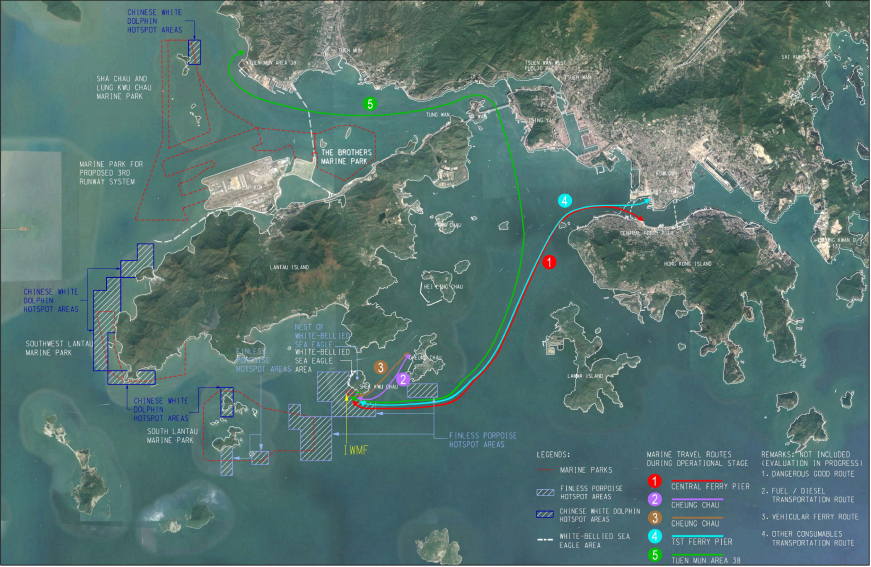
4.5.2) Active Acoustic Monitoring will be conducted by using the latest porpoise detector technology with a hydrophone component to record both background noise of vessel traffic and vocalizations of finless porpoises. Field work should be carried out at locations where traffic of MSW vessels and visitor/staff shuttle ferry is regular as shown in Figure 4.4 of the proposed marine travel routes during operational stage below. As evaluation on the marine travel routes design is still in progress in this stage, further confirmation on the monitoring locations for Active Acoustic Monitoring would be made in later stage of the Project, where AFCD and EPD shall be consulted before conducting the survey works.
|
|
Figure 4.4 Marine Travel Routes During Operational Stage |
4.5.3) Approximately 30 days of field work should be carried out during the peak months of occurrence of Finless Porpoise (December to May) The active acoustic monitoring service will be proposed to conduct concurrently with the land-based theodolite tracking and PAM survey during the same peak season of porpoise occurrence during operational phase. Details of the active acoustic monitoring methodology and frequency should be agreed with AFCD before the service is proceeded.
4.5.4) With the recorded data, analysis on whether the presence of, and distance from vessel traffic, would cause acoustic behavioural changes in Finless Porpoise, or changes in use of frequency range etc. could be determined. The results should be used to verify the predicted impacts and the effectiveness of the proposed mitigation measures to be implemented during the operational phase.
4.6) Precautionary Land-based Monitoring of Channel
4.6.1) Although the trapping of marine mammals within the open channel between IWMF and Shek Kwu Chau was predicted to be unlikely in the EIA report, in view of their conservation importance, the precautionary land-based monitoring of channel for potential trapping of marine mammals by site staff during the operational phase should be adopted to verify the impact predication.
4.6.2) The monitoring location shall be selected on the IWMF facilities with unobstructed view on the entire channel. As the detail operational design of IWMF is still in progress in this stage, further confirmation on the monitoring location for Precautionary Land-based Monitoring of Channel would be made in later stage of the Project, where AFCD and EPD shall be consulted before conducting the monitoring works.
4.6.3) During 1st year of operational phase of the IWMF, the monitoring shall be conducted once per week. Should any trapping occurs, the site staff must contact responsible parties immediately, i.e. AFCD and marine mammal specialist of the ET, for response and rescue.
4.6.4) The newly adopted construction option for seawall/breakwater in the application of VEP can also enhance the environmental performance by widening the open channel by 25% to 100% to improve the water circulation and hence the ecology of the surrounding waters.
5) Recommended Mitigation Measures to Avoid Disturbance to Marine Mammal.
5.1) The specific mitigation measures recommended in the approved EIA report shall be fully and properly implemented for the Project to minimize disturbance on Finless Porpoise during construction and operational phases.
5.2) Avoidance of peak season for Finless Porpoise occurrence
5.2.1) In order to minimize potential acoustic disturbance from construction activities on Finless Porpoise, the construction works that may produce underwater acoustic disturbance, if any, should be scheduled outside the peak months of occurrence of Finless Porpoise (December to May).
5.2.2) The construction works that may produce underwater acoustic disturbance shall be restricted within June to November. This approach would not only avoid the peak season for Finless Porpoise occurrence, but the magnitude of impacts arise from acoustic disturbance would also be minimized.
5.2.3) All specific construction activities that require avoidance of peak season for finless porpoise as mentioned in Clause 2.27of the FEP of the Project has been replaced by less acoustically disturbing construction methods such as Deep Cement Mixing and Precast Concrete Blocks Installation.
5.3) Opt for quieter construction methods and plants
5.3.1) Considering the sensitivity of marine mammals to underwater acoustic disturbance, instead of the previously proposed conventional breakwater and reclamation peripheral structure, which requires noisy piling works, the current precast concrete structure is proposed as an alternative option in addition to the steel cellular cofferdam method for the construction of seawalls and breakwaters, and DCM ground treatment will be adopted to provide stabilised and strengthened foundations to the seawalls and breakwaters of the Artificial Island.
5.3.2) It is anticipated that the ground treatment of DCM and the installation of precast concrete seawall and breakwater would not induce any underwater acoustic disturbance to finless porpoise. According to the results of the site trials for the Expansion of Hong Kong International Airport into a Three-Runway System, the DCM work is relatively quiet compared to other marine construction techniques, and the underwater noise generated was typically below 200Hz which is a frequency of low sensitivity for Finless Porpoises. According to Goold and Jefferson (2002), Finless Porpoises use narrowband and high-frequency ultrasonic pulses with peak energy of 142kHz. The underwater noise generated by the DCM ground treatment is well below the acoustic range of Finless Porpoises. Therefore, any noise generated by the DCM ground treatment would be negligible to finless porpoises.
5.3.3) Also, the precast concrete seawall and breakwater does not rely on embedment depth for structural strength and stability, therefore vibratory driving of the precast concrete seawall and breakwater into seabed is not required. In other words, unlike that of steel cellular cofferdam, the installation of precast concrete seawall and breakwater for the Artificial Island involves no use of vibratory hammer or hydraulic hammer and hence cause no underwater acoustic disturbance to finless porpoises.
5.3.4) Since the DCM ground treatment and the installation of precast seawalls and breakwaters should generate no underwater acoustic disturbance to Finless Porpoise, no specific mitigation measures are required.
5.3.5) Non-percussive bore piling method for the installation of tubular piles for the berth construction has also been avoided with the newly adopted installation of precast concrete structures.
5.4) Monitored exclusion zones
5.4.1) A monitored exclusion zone of 250 m radius from silt curtain or from the boundary of a work area should be implemented under the following situations (where applicable, Marine Mammal Watching Plan shall be conducted at the meantime):
1. 30 minutes before commencement of and during silt curtain installation/re-installation/relocation, deep cement mixing injection works or noisy construction works (as stipulated in FEP Clause 2.25 and 2.27); or
2. During implementation of MMEZ cluster plan with 3 or more construction vessels requiring Marine Mammal Observer (MMO)s duty operating simultaneously in close proximity.
The marine mammal exclusion zone (MMEZ) will be carried out in order to avoid the accidental entrance and entrapment of marine mammals within the silt curtains or works area and minimize underwater acoustic disturbance, so as for precautionary purpose for DCM works. If a marine mammal is noted within the exclusion zone, all marine works should stop immediately and remain idle for 30 minutes, or until the exclusion zone is free from marine mammals. The experienced MMO should be well trained to detect marine mammals. Binoculars should be used to search the exclusion zone from an elevated platform with unobstructed visibility. The MMO(s) shall be independent of the construction contractor and shall form part of the Environmental Team and have the power to call-off construction activities.
5.4.2) In addition, as marine mammals cannot be effectively monitored within the proposed monitored exclusion zone at night, or during adverse weather conditions (i.e. Beaufort 5 or above, visibility of 300 meters or below), marine works requiring the exclusion zone monitoring, should be avoided under weather conditions with low visibility as much as possible. For the night-time marine mammal monitoring, spotlight will be used to provide sufficient brightness to assist the inspection in dark condition. In case of inadequate of brightness, night vision device will be used. For the marine mammal monitoring during adverse weather, the MMO shall confirm the visibility of lookout point for effective implementation of the exclusion zone monitoring, whilst contractor shall confirm safety of MMO and practicability of deployment of silt curtain, otherwise marine works requiring the exclusion zone monitoring shall be ceased.
5.4.3) Marine Mammal Exclusion Zone (MMEZ) Plan is available in Appendix A, which has included details of exclusion zone monitoring works such as response plan for handling situation of spotting marine mammal by the MMO.
5.5) Marine mammal watching plan
5.5.1) Upon the completion of silt curtain installation/re-installation/relocation, the marine works would be conducted within an enclosed environment within the silt curtain. Subsequently, Visual Inspection of the Waters Surrounded by Silt Curtains (Section 2.1, MMWP) and Regular Inspection of Deployed Silt Curtain (Section 2.2, MMWP) inspection under Marine Mammal Watching Plan (MMWP) would be implemented (where applicable, Marine Mammal Exclusion Zone shall be conducted at the meantime).
As per EP requirement from Clause 2.13 of the VEP, a Marine Mammal Watching Plan has been prepared and submitted separately to EPD, where the plan has included details of marine mammal watching actions such as regular inspection of silt curtains and visual inspection of the waters surrounded by the curtains. All measures recommended in the Marine Mammal Watching Plan shall be fully and properly implemented for the Project.
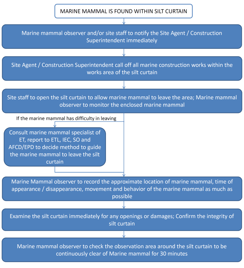
5.5.2) Special attention would be paid to Phase 2 (reclamation) where the floating type still curtain would be opened occasionally for vessel access, leaving a temporary opening. An action plan has been devised to cope with any unpredicted incidents such as the case when marine mammals are found within the waters surrounded by the silt curtains as below Figure 5.1:
|
|
Figure 5.1 Response Procedures for Occurrence of Marine Mammal within Silt Curtain |
5.6) Small openings at silt curtains
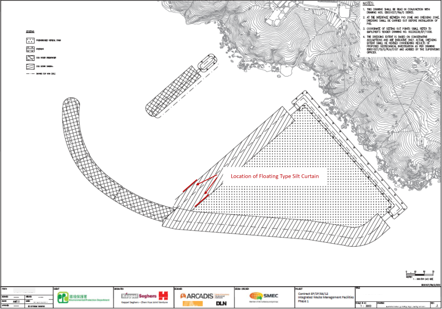
5.6.1) In order to avoid the entrance of marine mammals into the works area through the opening at silt curtains for vessel access, and the subsequent potential impacts including increase in stress level in marine mammals due to underwater noise and chance of collision with working vessels, the openings for vessel access at the silt curtains should be restricted to be from 50m-100m to minimize the risk of accidental entrance by marine mammal. Figure 5.2 below has illustrated the proposed location of installation of floating type silt curtain for vessel access during construction phase.
|
|
Figure 5.2 Location of Installation of Floating Type Silt Curtain |
5.7) Adoption of regular travel route
5.7.1) In order to minimize the disruption on marine mammals behavioural pattern during construction and operational phases, and minimize the chance of vessel collision with marine mammals, which may otherwise result in damage to health or mortality, captains of all vessels should adopt regular travel route. As per EP requirement from Clause 2.14 of the VEP, a Vessel Travel Details has been prepared and submitted separately to EPD, where the plan has included details of regular marine travel routes of vessels moving to and from the Project site during construction and operation stages.
5.7.2) The regular travel route should avoid areas with high sighting density of Finless Porpoise, as indicated in the latest Monitoring of Marine Mammals in Hong Kong Waters (AFCD, 2017), where no project vessel will travel, anchor and stopover the marine park and the hotspot area of Chinese White Dolphin and Finless Porpoise, except the area within IWMF construction site and its adjacent areas to traverse to and from the construction site. With the adoption of regular travel route, potential alteration in behavioural pattern of marine mammals due to increase in marine traffic is considered to be acceptable.
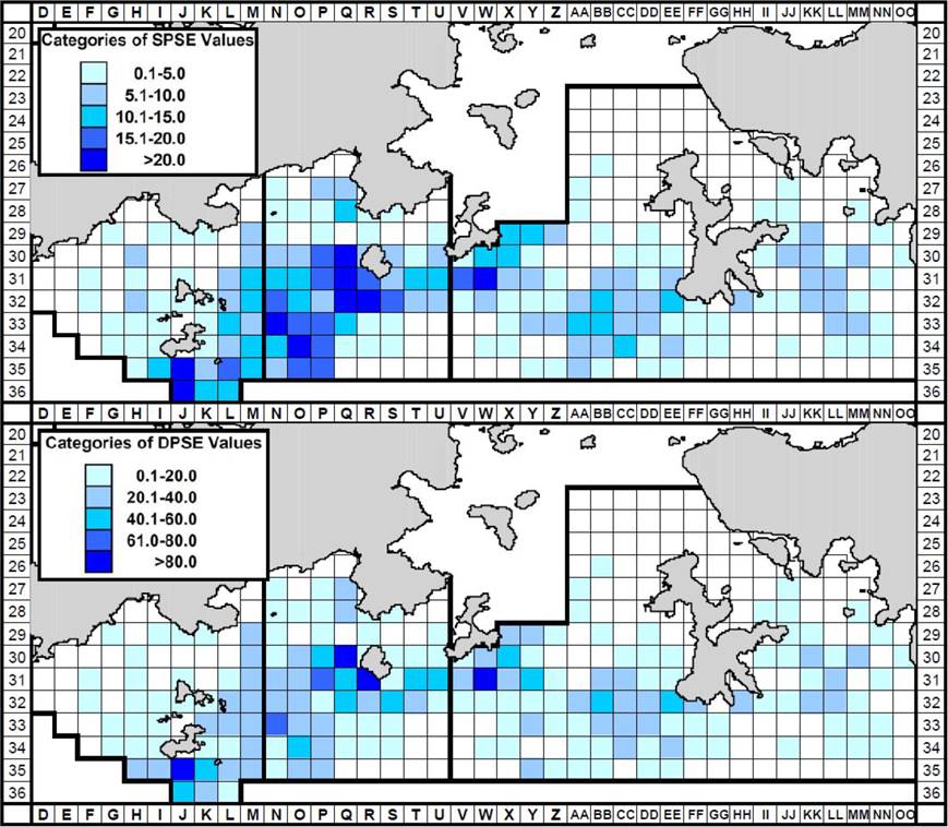
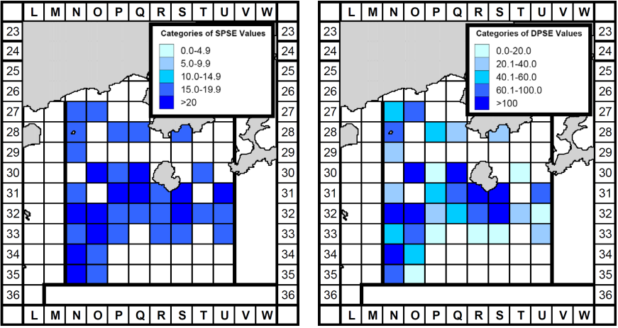
5.7.2) The setting of regular travel route should make reference to the sighting density of Finless Porpoise from the Final Report for Monitoring of Marine Mammals in Hong Kong Waters (2016-17) of AFCD and the baseline monitoring result of the pre-construction phase Vessel-based Line-transect Survey. The traveling vessels during peak season of porpoise occurrence should be paid with extra caution based on the information on porpoise density patterns in southern waters of Hong Kong between 2007-16 and the pre-construction phase survey between February to April 2018 as shown in Figure 5.3 and Figure 5.4 respectively, any marine routes with at least SPSE values of 15.1 or above in the long term AFCD survey data collected during 2007-2016 would not be used as a regular travel route.
|
|
Figure 5.3 Density of finless porpoises with corrected survey effort per km2 in southern waters of Hong Kong during peak season (December to May), using data collected during 2007-16 |
|
|
Figure 5.4 Density of finless porpoises with corrected survey effort per km2 in Southeast Lantau survey area during IWMF baseline monitoring period (February-April 2018) |
5.8) Vessel speed limit
5.8.1) In order to minimise potential injury and mortality of marine mammals due to collision with vessels during construction (working vessels) and operational phases (4 round trips per day for MSW vessel, and 12 round trips per day for visitor/staff shuttle ferry), a speed limit of ten knots should be strictly enforced within areas with high density of Finless Porpoise reference to Figure 5.3 and Figure 5.4. The vessels contracted for the Project will not travel, anchor or stopover the marine park and the hotspot area with at least SPSE values of 15.1 or above in the long term AFCD survey data, except the area within IWMF construction site and its adjacent areas to traverse to and from the construction site.
5.8.2) The other EP submission under VEP, Vessel Travel Details, has also provided more instructions and guidelines for the vessels driver to follow, including the below rules for vessel speed limit to be included in training sessions for all contract boat under IWMF:
· All vessels will travel at a speed no greater than 10 knots in the construction site area, which is demarcated by yellow marker buoys;
· The vessel captain should always remain a vigilant for the presence of Chinese White Dolphin / Finless Porpoise and make sure they slow down prior to passing known Chinese White Dolphin / Finless Porpoise hotspot areas, and take actions, e.g. never chases and cut across the course of Chinese White Dolphin / Finless Porpoise, to avoid disturbance to or collisions with Chinese White Dolphin / Finless Porpoise, the vessel shall travel less than 10 knots within the hotspot areas of Chinese White Dolphin / Finless Porpoise if unavoidable;
· Construction and associated vessels should not travel through, anchor or stopover at all existing Marine Parks in the western waters (including Sha Chau and Lung Kwu Chau Marine Park, The Brothers Marine Park), the planned Marine Parks in the western waters (including Southwest Lantau Marine Park, South Lantau Marine Park, and the proposed marine park for three runway system), and the hotspot area of Chinese White Dolphine and Finless Porpoise with reference to the long term AFCD survey data, if traversing the hotspot area is unavoidable (e,g. area within IWMF construction site and its adjacent areas to traverse to and from the construction site/due to safety reason), the vessel shall travel less than 10 knots.
5.8.3) The same speed limit has been enforced within the Sha Chau and Lung Kwu Chau Marine Park, and adopted under the EIA-172/2009 Hong Kong - Zhuhai - Macao Bridge Hong Kong Link Road (HyD, 2009a), where density of Chinese White Dolphin is high. Limitation on vessel speed limit has appeared to be effective in protecting dolphins from vessel collision, as well as minimising underwater acoustic disturbance. With the adoption of these mitigation measures, the potential impact marine mammals due to injury and mortality from vessel collision would be minimized to acceptable level. Passive acoustic monitoring and land-based theodolite monitoring surveys should be adopted to verify the predicted impacts and effectiveness of the proposed mitigation measures.
5.9) Training of staff
5.9.1) For the implementation of Marine Mammal Watching Plan and Marine Mammal Exclusion Zone Plan, training sessions shall be conducted for MMO by marine mammal specialist, Dr. Samuel Hung, Dr. Lindsay Porter, Ms. Julia Chan or someone with equivalent qualifications, with briefing materials provided as guidelines, instructing adequate knowledge of all requirements for observing marine mammal and appropriate actions to be taken according to this plan. Competence checking by ET shall be provided at least once every 6 months to the trained MMO involved in implementation of this plan.
5.9.2) As frontline staff of the main contractor or its sub-contractors, i.e. foremen, site agent, superintendents and engineers would involve in the implementation of this plan, briefings for these personnel will be provided by the trained MMO during induction trainings to get familiar with the plans for assisting on marine mammal observations within waters surrounded by silt curtains and taking necessary action according to the plans when there is marine mammal trapped by the silt curtain or appearance of marine mammal within the MMEZ. Refresh briefings will be provided to all frontline staff once every 6 months. The briefing and training records will be provided to ETL, IEC and SO for audit and record.
5.9.3) The contractor shall provide training to vessel captains to ensure vessel operation poses minimal risks to Chinese White Dolphin and Finless Porpoise. The training shall include briefings on predefined routes, general education on local cetaceans and white-bellied sea eagles, the required environmental practices / measures while operating construction and associated vessels under the Project, guideline for operating vessel safely in the presence of Chinese White Dolphin and Finless Porpoise. The contractor shall also schedule the training with individual marine contractors and shall ensure all marine vessel captains working on the Project are adequately briefed and trained prior to marine construction or prior to operating vessels within the construction site area. The same arrangement shall be adopted for vessel captains during operation stage. The training record shall be kept on site / office for both construction stage and operation stage. Participant shall sign his name and title on the training record.
6) Reporting Works for Monitoring of Marine Mammal
6.1) During construction phase and 1st year of operation of the IWMF, monthly marine mammal monitoring results should be incorporated into the Monthly EM&A Report of that reporting month and submitted to EPD and AFCD for comments within 2 weeks after the end of the reporting month by the ET.
6.2) The report should contain a summary of the survey findings during the reporting month, and assessment on the effectiveness of the mitigation measures implemented. Evaluation of results should take natural fluctuations and accidental human-induced events into account. The monitoring results between the EIA study, AFCD long-term marine mammal monitoring programme, and the pre-construction phase baseline monitoring, should be compared. Any significant difference should be identified and evaluated to verify the impact of IWMF construction works and evaluate the effectiveness of mitigation measures.
6.3) Status of the implementation of mitigation measures to minimise disturbance on finless porpoise of IWMF should be compared with the implementation schedule as listed in Appendix B during the monthly marine mammal monitoring.
7) Staff Organization
7.1) To meet the staffing requirements of the Project, a team of professionals leads by our qualified environmental professionals who are conversant with marine mammal monitoring surveys and Environmental Standards and Regulations in Hong Kong will be assigned. The curriculum vitae (CV) of our environmental experts are attached as Appendix C. The relevant experience and qualifications of the key staff to be deployed on the Assignment are highlighted below.
7.2) Relevant Experience and Qualification of Key Staff
l Ir. Dr. Gabriel Lam (CV1), BSc, MSc, PhD, FHKIE, FHKIOA, RPE, REA, CMIME.
Dr. Lam has more than 30 years practical experience in working as Project Director overseeing environmental consultancy projects especially environmental monitoring and audit, and independent environmental checker services. He will act as the Project Director to oversee the monitoring project.
l Mr. Kevin Li (CV2), BEng, MPhil, MHKIEIA, RAC.
Mr. Li has more than 10 years practical experience in working as a Project Manager managing and directing environmental monitoring and audit and independent environmental checker projects. He will act as the Assistant Project Manager for the coral translocation and monitoring and WBSE monitoring in this assignment.
l Dr. Samuel Hung (CV3), BA (Hons), MSc. PhD.
Dr. Hung is an experienced Marine Mammal Specialist. He has more than 20 years of ecology consulting and monitoring experience specializing in marine mammal in Hong Kong waters and will act as our Marine Mammal Monitoring Specialist in this assignment. He has an extensive portfolio in providing his expertise for the AFCD. He has also undertaken AFCD monitoring projects of marine mammals in Hong Kong waters since 2002. His experiences and knowledge with the AFCD organizational structure will be beneficial in providing an efficient communication process throughout this project and getting early approval on the marine mammal watching plans from AFCD.
l Dr. Lindsay Porter (CV4), B.Sc.(Hons), PhD.
Dr. Porter has spent the last 20 years in Asia working on species as diverse as largest of our oceans inhabitants, the blue whale, to one of the smallest, most elusive species, the finless porpoise. She will be our Marine Mammal Specialist in Finless Porpoise vessel-based and land-based monitoring as well as Passive Acoustic Monitoring (PAM). With a particular interest in inshore tropical delphinids, a lot of Lindsays work has focused on how these often localised populations interact and react to man and his activities. Lindsay sits on several regional and global policy and advisory boards which focus on the protection and conservation of marine mammals. With extensive experience at both NGO and government level, Lindsay sits on several regional advisory committees and is the focal point of several collaborative research projects within the South East Asian region.
l Ms. Julia Chan (CV5), B.Sc., M.Sc., MCIWEM, MHKIQEP
Ms. Chan has more than 19 years experience in environmental management and ecological monitoring and ecological monitoring and specialists in ecological impact assessment and monitoring (marine and terrestrial), biodiversity conservation, fisheries survey and impact assessment as well as the development of conservation strategy for ecological sensitive projects. She has been trained by the international marine mammals experts in conducting marine mammals survey since 2009 and experienced in conducting marine mammal impact assessment, recommendation of mitigation measures and guidelines in protecting marine mammals in Hong Kong. Julia will lead the marine mammal observers (MMO) training and ensure the performance of MMO team meets the expectation of the Authorities.
7.3) Adequacy of professional and technical manpower input will be arranged. Our project team has been allocated with sufficient manpower inputs to perform the tasks involved in this Assignment, deputy staff and technical officers have been assigned to cover up our project monitoring team members for construction and operational phases throughout the project period if necessary. Our Marine Mammal Specialist shall work alongside with our project team to prepare and review all EP submissions relating to marine mammal monitoring works throughout the Project.